Posts

Alleys in Urban Design: History and Application

A Short History of Alleys


Alley in Croatia by Dennis Jarvis

While alleys have existed in old world cities since the middle ages, they have had a limited level of utility in the recent American urban landscape. In the 19th century, American cities used alleys to hide the more utilitarian, less attractive functions of urban life including service and servant access, barns for horses and carriages, and even small shops and areas for children to play. However, the 20th century saw alleys nearly eliminated from the American urban landscape.


A number of events took place in the past century that contributed to the demise of the alley. Zoning segregated land use in such a way that many of the alley’s uses were redirected to distinct, separate districts. The automobile grew not only as America’s primary mode of transportation, but also as a status symbol. As such, home designs began to feature front loaded garages, allowing the automobile to be proudly displayed for all to see. Simultaneously, government spending focused on building high-speed roads and emphasizing home ownership, creating suburbs in lieu of cities. This “suburban” way of thinking about what communities should look like and how they should function was a shift away from compact, mixed-use development, causing alleys to be dismissed as costly wastes of space.


The Role of Alleys Today


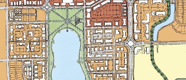
In the 21st century, Americans are once again embracing the benefits of urban life, including walkability and compact mixed use development. Along with this “new urbanism,” we find ourselves once again embracing the alley as playing a critical role in the function of our cities and community development. Alleys are now a common feature in the design and redesign of our communities.


An alley in Winter Park, Florida.

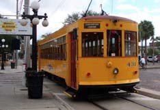
 An alley leads to shops and restaurants in Winter Park, Florida.


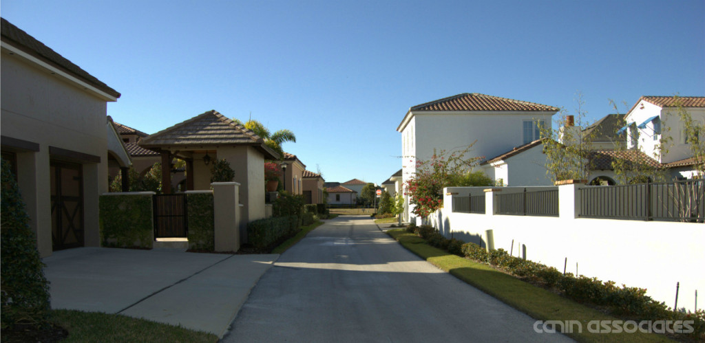
The primary role of alleys has traditionally been to hide the more unsightly functions of our communities; the garages, garbage cans, transformers, electric meters, and telephone equipment. However, today their other positive impacts are celebrated as well: making possible narrower lots as garages are now accessed from the rear as opposed to being a prominent feature in front of a residence, enhancing safety as sidewalks and pedestrians become separated from the access requirements of vehicles, providing additional building access for firefighters, and creating a more casual neighborhood space adjacent to back yard activity centers, which leave the front of the house as a more formal community space.


Additionally, alleys are regaining their historic function as access for accessory housing units, providing a greater diversity of housing choices within our neighborhoods. We are also finding new uses for alleys, such as the Green Alley Movement, started in Chicago, which transforms alleys into greener community spaces which perform their traditional functions in addition to beautifying neighborhoods and reducing rainwater runoff. In older cities, alleys are being rediscovered as people places.


Applying Alleys


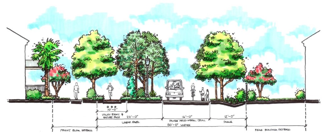
As with most urban design elements, a one-size-fits-all approach to alleys does not work. Alley specifications need to work within the framework of their surroundings. Alley design will vary depending on the uses within the alley: the character of residentially bounded alleys will differ from those that are found in commercial and industrial settings. Designers can implement a variety of alley sections, with variations occurring in pavement widths, garage setbacks, one-way or two-way access, parking locations, and service accessibility.


Alley-loaded homes in Baldwin Park, FL.

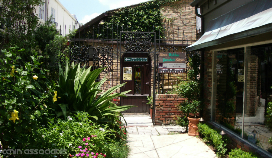
 Alley-loaded homes in Baldwin Park, Florida.


To ensure our new alleys work as they are intended, there is a need to coordinate the design, function, and development of alleys with many stakeholders. It’s not only designers that need to be involved in the process of determining what is the best alley design for a community or project, but also communities and their leaders, city planners, utility companies, solid waste removal providers, fire departments, public works departments, and developers all need to be brought to the table when alleys are being considered.


Event Recap: ULI Central Florida’s Volusia County Update

Leading the nation in job growth last year isn’t the only topic of discussion in Volusia County these days. With a major renovation of an iconic race track underway, cutting-edge research in aviation, and important infrastructure improvements in the works, ULI members and other attendees flocked to Daytona last week to hear the latest county news directly from the experts. The ULI Signature Event: Volusia County Update was held on April 30th at the Daytona International Speedway, drawing nearly 100 guests from around Central Florida and kicking off with a tour of the Daytona International Speedway. Attendees then met for the main event, moderated by Sans Lassiter, President of Lassiter Transportation Group, and featured presentations by Joie Chitwood III, Chris Kokai, and Martha Moore.


One Daytona Development


Joie Chitwood III, President of the Daytona International Speedway, shared not only the Speedway’s origins, but future plans to turn the track into a year-round attraction. For the first time in over 50 years, the Daytona International Speedway is getting a facelift. From seating improvements to upgraded amenities, the $400 million Daytona Rising project is underway to transform the race track into the world’s first motorsports stadium. But that’s not the only project slated for the area. Chitwood also gave visitors insight into One Daytona, a 190-acre, $800 million mixed-use development across from the Speedway. As expected, developments of this size don’t come without their fair share of challenges. For Chitwood and his team, a major challenge is meeting a construction schedule while still being able to operate the race track. Nonetheless, Daytona Rising and the first phase of One Daytona are expected to finish on-time in 2016.


Just next door to the Daytona International Speedway, Embry-Riddle Aeronautical University is researching aviation innovation. Florida Test Bed Director of Operations Chris Kokai gave a detailed overview of the Next Generation Air Transportation System, or NextGen. Part of the Florida Test Bed rapid prototyping initiative, NextGen aims to improve the airspace through technology “in ways that the general public may not notice.” Kokai and other researchers are modernizing air traffic control systems through homogenized data and better communication. Benefits for commercial airlines that bring tourists to Volusia County include more direct routes, increased fuel efficiency, and more frequent take-offs, all of which affect the way arrive at and depart airports like Daytona Beach International.


Just like aviation improvements, both local and regional infrastructure improvements will be needed to move residents and visitors around the county. That’s where Martha Moore, Vice President at Ghyabi & Associates, and her team come in as planning consultants for the International Speedway Boulevard Corridor Master Management Plan. Moore walked attendees through a variety of projects, including an additional pedestrian bridge and wider sidewalks connecting One Daytona with the Speedway, interchange improvements, an aesthetics master plan, and potential areas for multi-modal hubs.


Canin Associates is a proud sponsor of ULI Central Florida. For upcoming events, please click here.


Implementing Streetcars: Lessons from Atlanta

The streetcar fits a unique niche in our transportation system different from bus or light rail. It’s often described as an extension of the walking environment thanks to its ability to be used for short trips, while still connecting different neighborhoods within a city. However, as recent streetcar projects like the Downtown Loop in Atlanta have shown, their success requires patience.

streetcar_atlanta_downtown_loop

Photo © Matt Johnson via flickr

When to Implement Streetcars

In late 2014, Atlanta joined a growing number of US cities to add the modern streetcar to their available transit options. For Atlanta, the new Downtown Loop is the city’s first line since the original streetcar system closed in 1949. In a recent New York Times article, Keith T. Parker, the Chief Executive of MARTA, was quoted saying this about the new three-mile line:

“These are not projects for right now. These are projects for the future, and when you look around, the cities who we’re competing with around this nation and around the world, they’ve made investments in public transportation.”

This sentiment mirrors what we wrote in our previous post on streetcars: they are community builders. More than a mode of transportation, they aid in neighborhood revitalization. This means that cities can implement streetcars at strategic times and for specific purposes: to encourage transit-oriented development in new communities, to spur investment in underserved areas, or to provide a much-needed transportation alternative in bustling urban areas. No matter when streetcars are implemented in a city’s timeline, it takes time for them to become integrated into the urban landscape and into the habits of local residents and visitors—especially in places new to this type of fixed transit.

Where to Implement Streetcars

So perhaps it’s the growing pains of implementing a streetcar route in an existing urban fabric that has caused mixed reviews for Atlanta’s Downtown Loop. One notable piece was written by Atlanta magazine’s own Rebecca Burns, who chronicled her commute to work for an entire week using the new line. In addition to observing Atlanta’s overall lack of transportation options once at work, Burns’ biggest frustration was the speed of the streetcar: the line operates in regular vehicular traffic. While her ride provided shelter from the elements and a chance to catch up on email, in an auto-centric city of nearly half a million people, sometimes sitting in gridlock remains a reality.

streetcar_implementation_atlantaStill, a streetcar that operates in a regular traffic lane is not doomed to fail. One benefit of mixing the streetcar with cars is the ability to use an existing street lane without having to remove it. Taking out auto travel lanes can be controversial or impractical in many locations and completely new rails require additional planning and funding. However, in congested areas, an exclusive lane will make service not only faster but also more reliable and therefore more usable by non-tourist travelers.

Right now, the Atlanta Streetcar’s biggest challenge seems to be the need to prove its usefulness not only for tourists, but also for professional commuters, residents, and students. As the community grows around the new route and residents integrate it into their daily lives, the streetcar is sure to become an important cornerstone for downtown Atlanta.

 Photo © Central Atlanta Progress via flickr

A Brief Look: What is a Multi-Way Boulevard?

Streets, roads, courts, avenues, boulevards—cities use these words to name a range of street types. But in transportation design, each one describes a very specific type of thoroughfare. In this Brief Look, we’ll see what makes a thoroughfare a multi-way boulevard and why they are great placemaking solutions.

Typical Boulevard Plan View


The term “boulevard” is broadly used to describe a street or promenade planted with trees. For planners and engineers, however, a boulevard is also a highly valuable piece of roadway that can accommodate multiple users and types of movement within an urban design framework. We generally refer to this as a multi-way boulevard.

A multi-way boulevard contains three essential elements: central through lanes, parallel frontage lanes (coupled with an inviting pedestrian realm), and landscaped tree lawns (to buffer low speed users from through traffic). Beyond these core ideas, there can be a good deal of variety in the specific design, such as the location of transit and additional pedestrian or bicycle facilities.

One of the biggest challenges facing urban designers and traffic engineers is designing a roadway that accommodates the expectations of transportation officials while at the same time providing a safe, walkable environment that promotes pedestrian, bicycle, and transit uses. This is where the central through lanes provide the needed vehicular capacity, while frontage lanes create a calm, multi-use environment that lends itself to urban commercial and mixed-use development opportunities.

Boulevard with Streetcar


Multi-way boulevards come with many more benefits: they are aesthetically pleasing, accommodate on-street parking without interfering with through traffic, and create opportunities for buildings to interact with the sidewalk. Nonetheless, some challenges may exist in their application. Their higher cost and potential need for additional right-of-way must be acknowledged before design implementation can begin. Furthermore, a lack of existing engineering design standards means that only those with a strong understanding of roadway design can develop them.

From handling high volumes of traffic to providing fully functional pedestrian infrastructure, multi-way boulevards are a serious option for designing and redesigning large-scale thoroughfares in urbanizing areas.


The New Neighborhood: Mixed-Use and Multi-Modal

Conventional suburbs are making way for carefully master-planned neighborhoods with character. Outparcels remain a commodity along major thoroughfares, but are seamlessly integrated into the overall urban fabric of a budding community. In Southwest Florida’s Lake Flores, this concept is strengthened through two ideas: complete streets and multi-modal trails.


Lake Flores Florida Site Master Plan 3

Lake Flores bridges conventional commercial development and urban neighborhoods with thoughtful, multi-modal streets and trails.


Located near Sarasota, Lake Flores is an infill site of over 1,300 acres overlooking Sarasota Bay and just a few miles from the beach. This is the kind of special site that only comes available once in the life of a community. With the county’s How Will We Grow vision setting the stage for more mixed-use, urban development, the time is ripe for a game-changing new project that will set the tone for the next era of growth in this coastal community. After decades of ownership by the Manatee Fruit Company, this long-term venture has the potential to grow and evolve over a 20 year period.


Multi-Modal Trail Urban Planning

A landscaped multi-modal trail accommodates pedestrians, runners, cyclists, and small electric vehicles.


The heart of the plan is the community’s namesake, Lake Flores. This new nineteen-acre lake is surrounded by a green edge of park, which will provide a gathering place for the community and the region. Adjacent to the lake will be a new main street with restaurants and entertainment. Visitors can dine with a lake view or take an evening stroll after dinner. Apartments overlooking Lake Flores will create a peaceful, urban residential option convenient for a morning job and within easy walking distance of the main street. With two different business centers to accommodate commercial office as well as research and development, Lake Flores also provides the realistic opportunity to live and work in the same community.


Calm, carefully designed streets with opportunities for walking and biking both for recreation and practical transportation will be a priority at Lake Flores. A central multi-modal trail and linear park run the length of the site connecting all of the neighborhoods safely to the lakeside park and retail amenities. This trail is truly multi-modal, design to accommodate a soft path for runners as well as a hard surface wide enough for small electric shuttles. In addition, all streets are designed to be complete for all modes of transportation with buildings oriented to reinforce neighborhood character.


Streetcars Then and Now

Streetcars were a primary mode of transportation in America’s urban areas at the turn of the last century. In 1902, they carried 5.8 billion trips and provided quality transit service to compact, walkable cities. However, as cars began to dominate the post-war streetscape, streetcars fell from prominence.

Today, tastes in the United States are changing. Or, more accurately, they are leaning back to what they were before. Long commutes and worsening congestion are making urban and walkable lifestyles more desirable. With a changing national demographic that favors the urban life, cities are once again exploring streetcars as a way to catalyze the development and redevelopment of walkable neighborhoods.

Streetcars Old and New
Photo via Stephen Rees

Streetcars for Neighborhood Revitalization

Streetcars are more than just a form of transportation: They are city builders. But what type of development best compliments the streetcar? Generally, they are well-suited for higher-density, mixed-use buildings. A variety of mixes may include commercial, office, and residential uses. Residential densities should be at least 20 to 30 units per acre. Meanwhile, densities exceeding 100 units per acre can ensure good ridership.

Still, it’s important to remember that these mixes and densities don’t need to be present from day one. In fact, an essential role of streetcars is to help build such neighborhoods. Once established, they benefit from the ridership they produce. Fixed-transit provides a reliable development environment for private investors and an easy-to-understand first transit experience for new urban dwellers.

Streetcar installations have spurred high-quality, mixed-use development along corridors in cities such as Portland, Oregon; Kenosha, Wisconsin; and Tampa, Florida. In Portland, studies showed that the combination of streetcars and good development policies helped spur $2 billion dollars in private-sector investment. Meanwhile, the total public investment in streetcars was $57 million. Moreover, ridership was almost triple the initial projections.

Streetcar Types

Since its earliest conception, the streetcar has changed shape many times. Today, three varieties prevail. Each style has its benefits and drawbacks, but all three can compliment the character of the neighborhoods in which they’re placed.

Restored Historic Streetcar


  • Historic character
  • Typically lowest-cost vehicle
  • Difficult to find identical vehicles and parts
  • Low passenger capacity
  • ADA access at stops
  • Slower operating speeds and passenger boarding

Heritage Style Streetcar


  • Historic character
  • Lower vehicle cost
  • Simplified fleet maintenance
  • Low passenger capacity
  • ADA access at stops
  • Slower operating speeds and passenger boarding

Modern Streetcar


  • Modern image
  • Higher vehicle cost
  • Simplified fleet maintenance
  • Larger passenger capacity
  • ADA access in vehicles
  • Faster operating speeds and passenger boarding

The Benefits of the Modern Roundabout

Clearwater_Florida_Roundabout_Benefits
Image by Ken Sides, City of Clearwater
In 2007, the United States built its 1,000th roundabout. That same year, France built its 30,000th roundabout. Although countries around the world have taken the benefits of modern roundabouts to heart, this intersection solution has taken a little longer to grab hold in American municipalities. Nonetheless, as the benefits of this design become increasingly apparent (and needed), more and more intersections are following this circular model. So, what makes roundabouts so desireable?

Roundabouts Reduce Environmental Impacts

According to a study in Time Magazine, roundabouts cut hydrocarbon emissions at intersections by as much as 42%. By reducing idling, ten circular intersections in Virginia were found to save 200,000 gallons of gas each year. The “Gateway Roundabout” in Clearwater, Florida, replaced three signalized intersections and one stop-controlled intersection with a single two-lane traffic circle. Stop delays–and therefore emissions–were reduced by 68%. Likewise, similar interventions in Kansas were found to ease traffic delays by an average of 65%.

Roundabouts Are Safer by Design

Reduced risk when replacing intersections with roundabouts.Each year, over 30,000 individuals die in car crashes in the United States– and that doesn’t include the even greater number of annual crashes involving injuries to drivers and pedestrians. One solution to these high figures is the replacement of signalized and stop-controlled intersections with roundabouts.

The Federal Highway Administration (FHWA) and the Insurance Institute of Highway Safety found that replacing conventional intersections with roundabouts reduced overall collisions by 37%, collisions involving injuries by 75%, and collisions involving fatalities by 90%. Moreover, collisions with pedestrians were reduced by 40%.

Roundabouts Move More Cars

According to the FHWA, a single-lane roundabout can handle up to 2,500 vechilces per hour. It would take two travel lanes (and usually left and right turn lanes) in each direction to match that capacity. In other words, roundabouts handle more traffic with less pavement.


Overall, the benefits of these modern traffic circles are clear. While most traffic designers have caught on, it’s now up to local municipalities to allow for the conversion of conventional intersections.